Tuesday, May 3, 2011

The Colorado River

     The Colorado River is an important factor behind the formation of the Grand Canyon. As rocks begin to break, due to weathering, they fall down to the bottom of the canyon. The Colorado River then begins to push everything in its way and unclogs the mess.

Beautiful picture of the Colorado River flowing through the Grand Canyon


     The Colorado River is a meandering River, which means it's a single channel that wiggles across a flood plain. The Colorado River cuts and curves through the Grand Canyon. The outer curve of the river is deeper than the inside of the curve. The reason for this form is because the water at the end of the curve flows faster which then eats away at the land. This is called the cut bank. The water that flows closer to the curve flows slower which deposits particles; this is called the point bar.

The Colorado River swerves (meanders) through the Grand Canyon.

Diagram showing cut banks and point bars. Taken from Professor Allen's ppt.
Notice how the inner curve has deposits of particles and the outer curve is much deeper.

     Although it may not seem so powerful, the high velocity streams of the Colorado River are eroding the Grand Canyon. At times when the river is flowing rapidly, it triggers a process called corrasion which picks up debris and begins to grind within the channel. This process can create potholes. Also the water itself, without any debris, can erode the land by dissolving which is called corrosion.

Potholes created from corrasion.


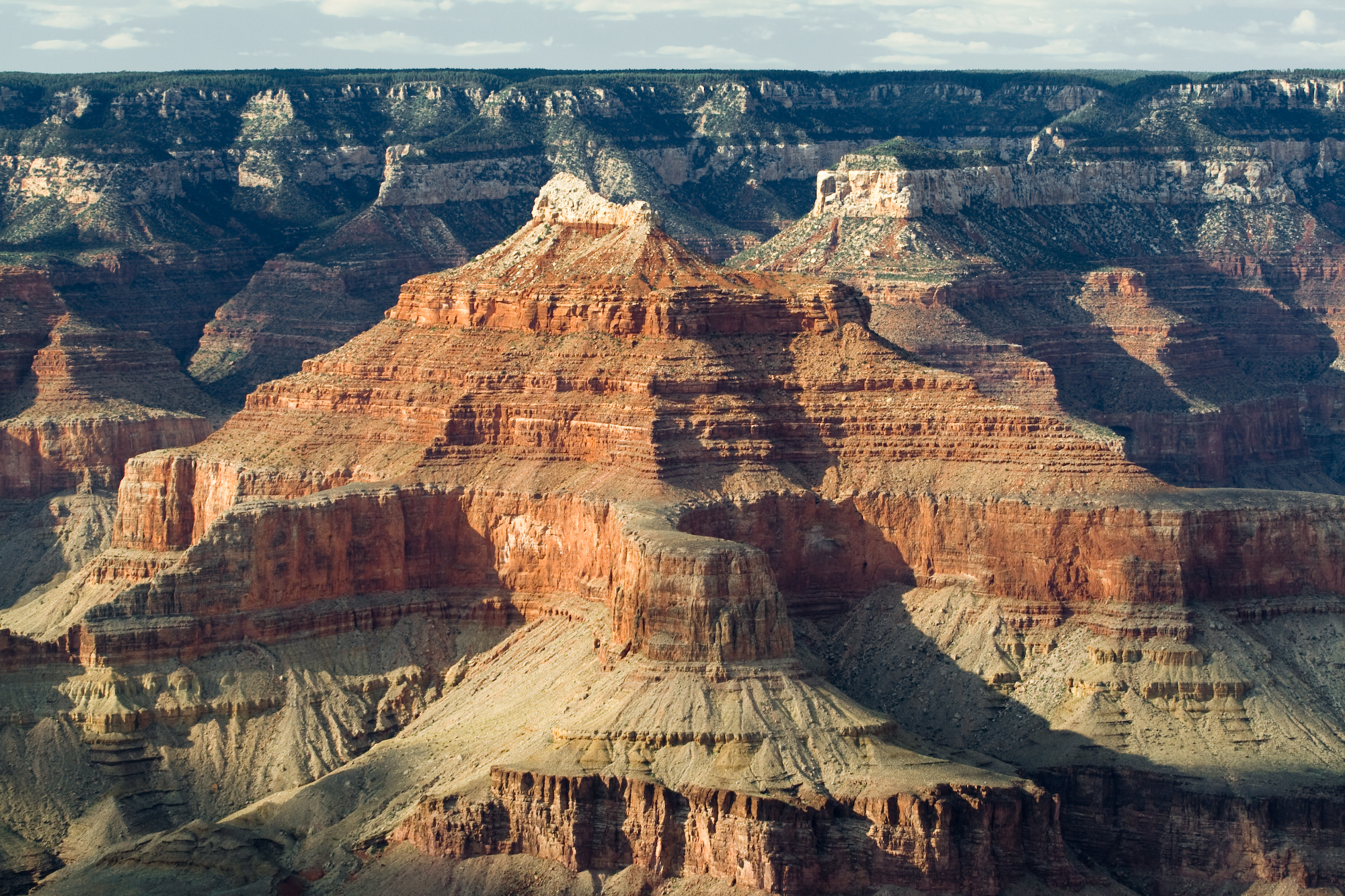
     Over long periods of time rivers can create beautiful fluvial landscapes. The Grand Canyon has many V-shaped valleys formed by erosion.


Notice how the canyon leads down to the river in a V-shape.

Works Cited
http://www.google.com/imgres?imgurl=http://www.grandcanyonflood.com/images/grand_canyon_colorado_river.jpg&imgrefurl=http://websites.computers4kids.net/~pkafley/ground%2520canyon.htm&usg=__AfyNUDdOcCB3-6w7-hM41yqwJJg=&h=480&w=640&sz=40&hl=en&start=0&sig2=HouIqrLnjEk3ImsSFAUYaQ&zoom=1&tbnid=XU1eDDg9-ozA8M:&tbnh=140&tbnw=191&ei=SkrATZq8MpP6swPjk9CTCA&prev=/search%3Fq%3Dgrand%2Bcanyon%2Briver%26um%3D1%26hl%3Den%26client%3Dfirefox-a%26sa%3DN%26rls%3Dorg.mozilla:en-US:official%26biw%3D1152%26bih%3D622%26tbm%3Disch&um=1&itbs=1&iact=hc&vpx=696&vpy=321&dur=2349&hovh=194&hovw=259&tx=208&ty=153&page=1&ndsp=15&ved=1t:429,r:13,s:0

http://fast.ucdenver.edu/case/1202/Landscapes/Fluvial/PointBarCutBank.jpg

http://www.google.com/imgres?imgurl=http://photography.nationalgeographic.com/staticfiles/NGS/Shared/StaticFiles/Photography/Images/POD/w/water-puddle-nichols-1048902-sw.jpg&imgrefurl=http://photography.nationalgeographic.com/photography/enlarge/water-puddle-nichols_pod_image.html&usg=__fKh7Xd4EQymR2JOIS40jjfg9P7A=&h=600&w=800&sz=148&hl=en&start=0&sig2=RJQ51aitbJoqj4mXi37U1A&zoom=1&tbnid=Z4nl7wcXgckFuM:&tbnh=140&tbnw=171&ei=e0vATZvJGoiosQOD6dSTCA&prev=/search%3Fq%3Dgrand%2Bcanyon%2Bpotholes%26um%3D1%26hl%3Den%26client%3Dfirefox-a%26rls%3Dorg.mozilla:en-US:official%26biw%3D1152%26bih%3D622%26tbm%3Disch&um=1&itbs=1&iact=hc&vpx=308&vpy=321&dur=4639&hovh=194&hovw=259&tx=169&ty=69&page=1&ndsp=16&ved=1t:429,r:12,s:0

https://blogger.googleusercontent.com/img/b/R29vZ2xl/AVvXsEiJSyXAtqL8Sdlun6cVBtKrYjW4Sw495xsLRaeAdQmpX0RmPHpvmXtoZMTMl8KnysfWJe_9sw9XB3eOIy8KGiyFp0gGMt8qHHGXZbXI2R26gpARp7RhlENsgxEeh08KlunVic3JCZgpLJ0/s1600/Nature_Mountains_Grand_Canyon_018928_.jpg

https://blogger.googleusercontent.com/img/b/R29vZ2xl/AVvXsEiJSyXAtqL8Sdlun6cVBtKrYjW4Sw495xsLRaeAdQmpX0RmPHpvmXtoZMTMl8KnysfWJe_9sw9XB3eOIy8KGiyFp0gGMt8qHHGXZbXI2R26gpARp7RhlENsgxEeh08KlunVic3JCZgpLJ0/s1600/Nature_Mountains_Grand_Canyon_018928_.jpg

http://www.scienceclarified.com/landforms/Basins-to-Dunes/Canyon.html

Thursday, April 7, 2011

Temperature and the Weather

          Arizona is located in the southwestern region of the United States with the coordinate points 33 degrees N and 112 degrees W. Arizona is notable for its intense desert climates which produce hot summer days and mild winter days.

Arizona is notable for desert landscape.

          Some parts of Arizona experience 5 seasons per year: summer monsoon, autumn, winter, spring, and fore summer drought. From July to September is the rainy season. November through February are the coldest months of the year with an average minimum temperature 60 degrees F. Then finally from May to July are the hottest months of the year with temperatures ranging from 90-128 degrees F with little or no rain.

Chart shows the temperature and precipitation of Arizona throughout the year.

          During the summer monsoon, from July to September, Arizona experiences a summer rainy season with an annual rainfall of 13 inches. During this time a "tropical air mass adds humidity and moderates June's extreme temperature." With the hot moisture in the air along with rising unstable air, creates lightning and thunderstorms.

Rain in the Grand Canyon.

Hot moisture air along with rising unstable air creates lightning and thunderstorms.

As the cold air descends, the moisture air condenses and produces Valley Fog.

          With the presence of a thunderstorm, comes a dangerous feature, the haboob, a huge dust wall. As air descends from a thunderstorm, it then crashes into the ground creating an enormous gust front. These haboobs are usually found in desert regions. Even though downward movement of air may not seem to be a problem, it can be quite dangerous to nearby planes. The rapid wind can cause planes to descend, which can be hazardous during times of takeoff and landing.


Diagram of a Gust Front. Taken from Professor Allen's ppt.


Works Cited:
http://www.google.com/imgres?imgurl=http://farm1.static.flickr.com/23/183526432_7f3477b1ef.jpg&imgrefurl=http://www.flickr.com/photos/matthewphx/183526432/&usg=__SZFPjOqDUm1BCuJaMIff5OlreT0=&h=375&w=500&sz=198&hl=en&start=0&sig2=tWmKOjAP1xuHTe3tk3yJcg&zoom=1&tbnid=FlawBKKnle-QGM:&tbnh=154&tbnw=225&ei=whaeTbzGCYa0vwPIlcTABA&prev=/images%3Fq%3Darizona%2Bdeserts%26um%3D1%26hl%3Den%26client%3Dfirefox-a%26rls%3Dorg.mozilla:en-US:official%26biw%3D1280%26bih%3D810%26tbm%3Disch&um=1&itbs=1&iact=hc&vpx=759&vpy=131&dur=962&hovh=194&hovw=259&tx=123&ty=134&oei=whaeTbzGCYa0vwPIlcTABA&page=1&ndsp=20&ved=1t:429,r:3,s:0

http://www.usclimatedata.com/climate.php?location=USAZ0077

http://www.google.com/imgres?imgurl=http://farm1.static.flickr.com/51/171020876_ef413286bf.jpg&imgrefurl=http://www.flickr.com/photos/jwoodphoto/171020876/&usg=__nttrVxiHrTNYdjqfdHsQhQ08gyc=&h=336&w=500&sz=57&hl=en&start=0&sig2=HZkpSRBOii6XJV-iYY_Liw&zoom=1&tbnid=ABG3Mzmvd9z4UM:&tbnh=158&tbnw=183&ei=-hyeTaKtCIOWvAPi4rXEBA&prev=/images%3Fq%3Dgrand%2Bcanyon%2Bthunderstorm%26um%3D1%26hl%3Den%26client%3Dfirefox-a%26hs%3D8ub%26rls%3Dorg.mozilla:en-US:official%26biw%3D1280%26bih%3D810%26tbm%3Disch&um=1&itbs=1&iact=hc&vpx=99&vpy=94&dur=542&hovh=184&hovw=274&tx=213&ty=71&oei=-hyeTaKtCIOWvAPi4rXEBA&page=1&ndsp=20&ved=1t:429,r:0,s:0

http://www.google.com/imgres?imgurl=http://photography.nationalgeographic.com/staticfiles/NGS/Shared/StaticFiles/Photography/Images/POD/l/lightning-grand-canyon-nichols-983558-ga.jpg&imgrefurl=http://photography.nationalgeographic.com/photography/photos/best-pod-june-08/lightning-grand-canyon-nichols_pod_image.html&usg=__iPusKb73hsEnNMBDF6iTsHkbo2w=&h=325&w=470&sz=40&hl=en&start=0&sig2=3isFqat07VL-v-vPz4HApQ&zoom=1&tbnid=dmQ45hyaB5BUiM:&tbnh=160&tbnw=213&ei=8hyeTa25BJCSuAOV8ZG2BA&prev=/images%3Fq%3Dgrand%2Bcanyon%2Blightning%26um%3D1%26hl%3Den%26client%3Dfirefox-a%26hs%3D4Zw%26rls%3Dorg.mozilla:en-US:official%26biw%3D1280%26bih%3D810%26tbm%3Disch&um=1&itbs=1&iact=hc&vpx=141&vpy=94&dur=2258&hovh=187&hovw=270&tx=230&ty=149&oei=4xyeTazVK4OWvAPi4rXEBA&page=1&ndsp=20&ved=1t:429,r:0,s:0

http://fast.ucdenver.edu/case/1202/Climate/Weather/gustfront.gif

http://www.youtube.com/watch?v=3TH_4lL_DjE&feature=related

http://www.google.com/imgres?imgurl=http://sdpemail.com/roadtrips/GC/Gr%2520Can%2520view%2520fog%2520and%2520clouds.jpg&imgrefurl=http://sdpemail.com/roadtrips/GC/grandcanyon.html&usg=__VG37CbW7WJzODNfzhhH_c68hbTo=&h=685&w=1024&sz=496&hl=en&start=42&sig2=WKhjKpx11YNOs2sDrMvGBA&zoom=1&tbnid=8Gi7oNYMJ3a7sM:&tbnh=148&tbnw=205&ei=miGeTeLgAYSsugPTmIC7BA&prev=/search%3Fq%3Dgrand%2Bcanyon%2Bfog%26um%3D1%26hl%3Den%26client%3Dfirefox-a%26sa%3DN%26rls%3Dorg.mozilla:en-US:official%26biw%3D1280%26bih%3D810%26tbm%3Disch0%2C1824&um=1&itbs=1&iact=hc&vpx=568&vpy=186&dur=1480&hovh=184&hovw=275&tx=185&ty=143&oei=diGeTZeYJIy0vgPo7_SqBA&page=3&ndsp=21&ved=1t:429,r:18,s:42&biw=1280&bih=810

Thursday, March 3, 2011

Weathering and Mass Wasting

          Many people who visit Arizona assume that the Colorado River is the main reason for the beautiful formation of the Grand Canyon.  Even though, the Colorado River does play an important role, there are other factors behind the Grand Canyon's design. 


Beautiful scenery of the Grand Canyon!

          Weathering, which is the process of breaking down rocks in place, is a big factor for the Grand Canyon. Because of faulting, the Grand Canyon begins to break down creating joints in rocks. These joints are spaced cracks and fractures that are very sensitive to pressure. Then weathering breaks down these weak spots into smaller pieces. A specific example of physical weathering is pressure of roots.  Plant roots can grow into cracks causing the rocks to expand and eventually to break.

Several trees and rocks have fallen from the canyon due to Pressure of Root Weathering.

Different ways rocks are broken.  Taken from Professor Allen's power point.


As you can see, there are major cracks and fractures in the rocks.

         As these rocks break and collapse, they fall or slide down to the river due to gravity. This then triggers a new process called Mass Wasting, which is the downslope movement of angular slope materials. Since these rocks are now displaced at the bottom of the canyon, the Colorado River begins to push everything is its way. The Grand Canyon is wide because of Mass Wasting and the Colorado River just unclogs the mess.  The Colorado River is like Drano down a toilet!

Process of weathering and mass wasting. Taken from Professor Allen's powerpoint.

          Since Mass Wasting moves the materials down the canyon, all that remains are slopes. These slopes are very beneficial to our lives because they are sources for ground water, which can be extracted for drinking water. But too much removal of water from the ground (Ground Subsidence) can cause compaction in the land.

The slopes are sources for ground water. Taken from Professor Allen's power point.

The ground level has gone down due to Ground Subsidence. Taken from Professor Allen's Power point.


Works Cited:
http://www.google.com/imgres?imgurl=http://www.zastavki.com/pictures/1600x1200/2009/Nature_Mountains_Grand_Canyon_018928_.jpg&imgrefurl=http://www.zastavki.com/eng/Nature/Mountains/wallpaper-18928-2.htm&usg=__AbUwIyvRYwTwTmfjboThbFYec2I=&h=1200&w=1600&sz=703&hl=en&start=60&sig2=xMOdrrZLKPofBD1OVXw-Sw&zoom=1&tbnid=yFTOwQLEcrJ34M:&tbnh=135&tbnw=172&ei=k_tvTenaOIWosAOhu73NCw&prev=/images%3Fq%3Dgrand%2Bcanyon%2Bwallpaper%26um%3D1%26hl%3Den%26sa%3DN%26rlz%3D1C1CHFX_enUS398US398%26biw%3D1280%26bih%3D909%26tbs%3Disch:10,1400&um=1&itbs=1&iact=hc&vpx=310&vpy=283&dur=164&hovh=194&hovw=259&tx=181&ty=92&oei=LPtvTZ3lDIbCsAPv7NzSCw&page=3&ndsp=30&ved=1t:429,r:1,s:60&biw=1280&bih=909

http://www.youtube.com/watch?v=lN0cZg_9XeM

http://www.youtube.com/watch?v=XdcGqPdHN44

http://www.google.com/imgres?imgurl=http://www.silverspurtours.com/gfx/lake-powell-river-bend.jpg&imgrefurl=http://www.silverspurtours.com/air-jeep-river-float.php&usg=__SFKq_4wlH1EaPfDOhi4fV9XfGEo=&h=265&w=400&sz=28&hl=en&start=41&sig2=TBxbajLFfK2WdqLLtHH9hw&zoom=1&tbnid=kq416j2WKQ6y3M:&tbnh=167&tbnw=229&ei=ZgFwTfjyF4u-sQPvhfGtDw&prev=/images%3Fq%3Dgrand%2Bcanyon%2Briver%26um%3D1%26hl%3Den%26rlz%3D1C1CHFX_enUS398US398%26biw%3D1280%26bih%3D866%26tbs%3Disch:10,1500&um=1&itbs=1&iact=rc&dur=287&oei=PAFwTczhHIu4sQORqInECw&page=3&ndsp=20&ved=1t:429,r:14,s:41&tx=141&ty=60&biw=1280&bih=866

http://fast.ucdenver.edu/case/1202/Battle/Destroy/Wx/Weathering/DiagWhichCorrect.jpg

http://fast.ucdenver.edu/case/1202/Battle/Destroy/MassWasting/slidetypes.jpg

https://blogger.googleusercontent.com/img/b/R29vZ2xl/AVvXsEiWUL0xmQ2qwUFy7QZ-ZTqRGGEUDQpj49EtEH6zZCnQh1kAuTxZrBm3hRTcX51Pfl0lqBt84L63PMEEKrv6WIcTPGDTN9FS4kyxQ5eUOlM0NHziVd0qGe7BbdYs4EsbdrdvLmc3OAAW5ta2/s1600-h/grand-canyon-sunset-4.jpg

http://fast.ucdenver.edu/case/1202/Battle/Destroy/Hydrology/AZFissures1.GIF

Tuesday, February 15, 2011

Grand Canyon Rock Strata and Vulcan's Throne

          The Grand Canyon is one of the most beautiful National Parks in the United States. It is about 277 miles long and about a mile in depth. I am really fasinated by the different types of colorful rock strata that makes up the Grand Canyon.

http://upload.wikimedia.org/wikipedia/commons/f/fe/USA_09855_Grand_Canyon_Luca_Galuzzi_2007.jpg

          There are many layers of rocks that form the Grand Canyon. These layers are called Strata, which are sedimentary rocks that are deposited in layers.  The canyon is composed of different kinds of sedimentary rocks such as: shale, sandstone, limestone, and granite. All of these rocks have lithified over time. Geologist use these rock layers to research and learn more about Geological Time Scale, which describes event that occured millions of years ago.

Geological Time Scale
http://en.wikipedia.org/wiki/File:Geologic_Clock_with_events_and_periods.svg
          The Time scale above describes the history of the universe. The top layers of the Grand Cayon was formed during the Paleozoic Period, over 250 million years ago. As you go down the cayon, the sedimentary rocks get older.

Diagram shows the different layers of sedimentary rocks
http://upload.wikimedia.org/wikipedia/commons/1/14/Stratigraphy_of_the_Grand_Canyon.png
               The reason for this formation is due geological processes like uplift of land, breaking down of surrouding land, faulting,weather, and water erosion. Scientist have stated that these processes have been going on for millions of years. These processes also form horst and grobins, mountians, and hills.

          Along with the Grand Canyon, Arizona is also home to another geological site, the Vulcan Volcano. The Vulcan Volcano is cinder cone volcano located on the north rim of the Grand Canyon. When pieces of rock, tephra, are ejected out of the volcano, the tephra falls back down creating a plyroclastic volcano and also forming very small crystals..

Images of Vulcan Volcano

Formation of Cinder Cone Volcano (used from Dr. Casey's ppt)
http://fast.ucdenver.edu/case/1202/Battle/Build/VolcanicEx/tephra_diagrams.gif

Works Cited:
http://fast.ucdenver.edu/case/1202/Battle/Build/VolcanicEx/tephra_diagrams.gif
http://upload.wikimedia.org/wikipedia/commons/1/14/Stratigraphy_of_the_Grand_Canyon.png
http://en.wikipedia.org/wiki/File:Geologic_Clock_with_events_and_periods.svg
http://upload.wikimedia.org/wikipedia/commons/f/fe/USA_09855_Grand_Canyon_Luca_Galuzzi_2007.jpg
http://www.und.edu/instruct/mineral/101intro/grandcanyon/grandcan.htm
http://www.obsidianlab.com/pan_toroweap/vulcans_throne_pan.html
http://www.extremescience.com/zoom/index.php/volcanoes/31-cinder-cone-volcanoes
http://www.bobspixels.com/kaibab.org/geology/gc_layer.htm#kl
http://en.wikipedia.org/wiki/Grand_Canyon#Geology

Wednesday, January 26, 2011

Introduction


           Arizona is more than just Iced Tea. Arizona is the home of the great Grand Canyon, beautiful desert landscapes, and amazing mountains and plateaus.  This wonderful state of Arizona has captured the hearts of many tourists over the years. With its stunning scenery, Arizona attracts more than 35 million tourists a year.  Although Arizona was one of the last states to join the United States, it is one of the first states that lures Americans with its geographical beauty.


http://wallpapers.boolsite.net/srv10/Images/Wallpapers/Nature_Paysages/Montagnes/GrandCanyon03.jpg

            Hello, my names Abdullah Zullali. I'm a sophomore majoring in Civil Engineering. I chose the state of Arizona for my Blog because of its long and unique geographical history.  Just one glimpse of Arizona, one would notice the vast and beautiful landscapes that it possesses. Although I've never been to Arizona, I would like to travel there in the future. Seeing the would famous Grand Canyon and Meteor Crater would be an awesome way to spend the summer break.